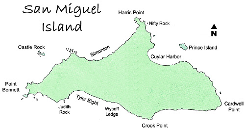
The California coast runs nearly east to west from Point Conception to Ventura. San Miguel Island is directly south of this coastline, about twenty-seven miles offshore from Point Conception. The fourteen square-mile island is subject to high winds, and bears the brunt of heavy surge and currents.
San Miguel's coastline is twenty-seven miles of steep cliffs and tumbled rocks, dotted with occasional sandy beaches. The westernmost of these is Point Bennett, the only place in the world where you can find as many as six different species of pinnipeds. In the winter, tens of thousands of sea lions and seals can be seen on the Point. In early spring, the island's rolling slopes are ablaze with a thick blanket of colorful wildflowers. Summer and fall are dry months, but the wind-swept grasses and numerous species of sea birds create an austere beauty. San Miguel is rugged and spectacular topside, but even so, the most awesome sights at the island are found underwater.
A Treefish and Monterey Dorid in a garden of invertebrates at Wyckoff Ledge:
Wyckoff Ledge epitomizes the stunning underwater beauty of San Miguel Island. Situated on the south side of the island, halfway between Tyler Bight on the west and Crook Point on the east, the divesite is a few hundred meters offshore. If you know where to look on the surface, you can pinpoint the Ledge with the help of the giant perennial kelp. Macrocystis pyrifera grows at Wyckoff and Tyler Bight in great abundance. On the outside where the Ledge drops off sharply, the kelp disappears. The line on the surface where the kelp ends delineates the edge of the long, steep wall beneath.
The kelp grows thick at Wyckoff Ledge:
The underwater environs of the northern Channel Islands are dense with life because of a phenomenon known as upwelling. In a nutshell, upwelling is the nutrient-rich water of the deep ocean flowing upwards into shallow zones. Upwelling occurs when water along the shore is drawn away, and water from an adjacent area of deep ocean flows in to replace it. Areas with large amounts of deep water upwelling have super-charged marine life. The forces required for deep water upwelling come together in just a few places on earth. San Miguel Island sits on the leading edge of one of them. The upwelling of nutrient-rich water fuels the habitat for an amazing density of marine creatures, all interlocked with one another in a web of life.
White Dendronotus nudibranchs (and many others) abound at Wyckoff:
For underwater photographers, the upwelling is the same reason you'll want a drysuit, and need excellent diving skills. The water is fairly cold - 50° (10° C) - and you need to be prepared for current, surge, and low vis. As grim as this may sound to some, Wyckoff Ledge is among my favorite places to shoot underwater images. It's the best-of-the-best of California's northern Channel Islands.
Orange and red variations of the Club-tipped Anemone Corynactis californica:
The story of Wyckoff's abundant life is the story of the ocean itself. The first chapter begins far south, in the ice surrounding the Antarctic continent. Freezing saltwater re-deposits minerals and salts back into the sea, creating super-dense saltwater. This super-salty water is heavier than the surrounding surface water, and so it slides down the slopes of the subcontinent, to the bottom of the Southern Ocean. As consulting a map of the globe will show, the Southern Ocean is connected to all the major oceans of the world. The inflowing water displaces the icy water at the bottom, and in a domino effect, all the world's oceans are set in motion. In the Pacific, the water flows northward along the deep bottom past Polynesia, all the way up the eastern side of the Pacific. These deep water currents run very slowly, in a clockwise direction around the Pacific Rim.
White and brown Metridium senile anemones cover vast areas of Wycoff Ledge:
As the deep Pacific current moves in this slow circuit, it gathers up and carries along with it the marine snow - tiny bits of debris from the ocean's upper layers. The marine snow is made up of zooplankton, single-celled plants called diatoms, animal larvae, and detritus, all drifting downwards from the sun-lit water above. As these fall, the organic compounds are broken down by bacteria into proteins, DNA, and sugars, and then further into carbon, nitrogen, and phosphates. Marine snow is the foundation of the oceanic food chain because it feeds the oceans' phytoplankton, the first link in the chain.
A Giant Acorn barnacle among anemones, and two Noble Dorids in a barnacle shell:
The next chapter of the story takes place in the air above San Miguel Island. As you may know, wind is created as air in high latitudes over a large land mass cools and sinks. The trade winds blowing over San Miguel are created by the temperature differences in the air above the Pacific ocean verses the North American continent. The constantly blowing wind drives a rapid surface current that circumnavigates the entire North Pacific, called the North Pacific Gyre.
Zooid of the social tunicate Clavelina huntsmani, and a Kelp Rockfish:
Turning right at Alaska, the North Pacific Gyre carries the surface water south, down the coastline of western North America. It begins its westward turn at Point Conception, California, pushed by the winds blowing off the continent and the shape of the shoreline. San Miguel Island stands directly in the bending current's path.
A Wolf-fish, and an Island Kelpfish:
As the surface current turns offshore, cold water from the adjacent depths is siphoned upward to fill a void created by the rapidly flowing water. The marine snow, concentrated by the deep currents, is swept up into the shallow zone surrounding California's northern Channel Islands, and San Miguel is first in line. The abundant nutrients cause the phytoplankton to bloom, and become the first link in a glorious web of life. -Ken Ashman